Ba Ria - Vung Tau
Coastal running paths with stunning sea views and challenging hill climbs.
All Routes
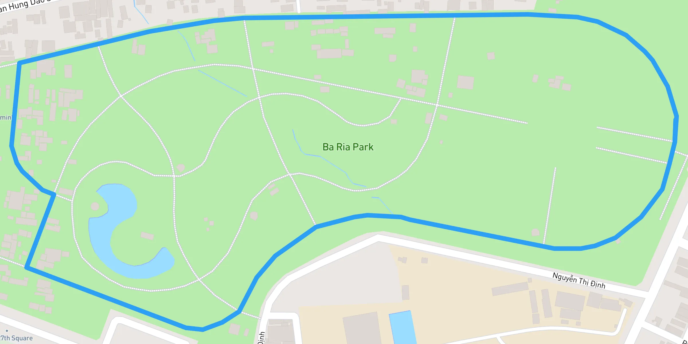
A peaceful urban park in Ba Ria offering wide, shaded paths perfect for casual jogs and family runs, surrounded by greenery and open spaces. Located in the heart of Ba Ria City in Ba Ria–Vung Tau province, the Ba Ria Park Running Route offers locals and visitors a refreshing green space perfect for daily jogs, walks, or leisurely runs. Below is a comprehensive look at what makes this route an excellent choice for runners of all levels. ## 1. Overview and Highlights - **Scenic Urban Park:** The park features broad, tree-lined paths that provide ample shade, making it comfortable even during warmer hours. - **Family-Friendly Atmosphere:** With playgrounds, wide promenades, and benches for relaxation, the park is an ideal spot for family outings. - **Fitness Facilities:** Some sections of the park include simple exercise equipment, so you can diversify your workout beyond running. ## 2. Route Details 1. **Distance & Terrain** - The main loop around the park spans about 1.5 to 2 kilometers, depending on how you navigate the pathways. - Most of the route is flat and paved, suitable for a smooth, consistent run. 2. **Ideal Times to Run** - **Early Morning (5:30–7:00 AM):** Enjoy cooler temperatures and fewer crowds; witness local residents participating in tai chi or light aerobics. - **Late Afternoon (4:00–6:00 PM):** Pleasant golden-hour lighting, with moderate foot traffic that can help motivate you to keep pace. ## 3. Points of Interest - **Central Pond or Fountain:** Many urban parks in Vietnam feature a water element. If Ba Ria Park has a pond or fountain area, it’s likely a scenic centerpiece to lap around. - **Flower Gardens:** Depending on the season, you may spot well-maintained flowerbeds that add color and vibrancy to the park. - **Local Vendors:** Near main entrances, you’ll often find vendors selling fresh fruit, snacks, and bottled drinks—perfect for a quick energy boost. ## 4. Safety and Comfort 1. **Restrooms** - Public facilities are typically located near park entrances or central areas. Note the operating hours, as some facilities may close early. 2. **Hydration** - While local stalls and convenience stores near the park may sell bottled water or sports drinks, consider bringing a reusable bottle if you plan a longer run. 3. **Weather Preparedness** - Summers in Ba Ria can be hot and humid. Wear lightweight, breathable clothing and apply sunscreen to shield against UV rays. 4. **Evening Runs** - The park’s pathways are generally well-lit, but be mindful of dimmer sections if running after sunset. Reflective gear or small running lights can improve visibility. 5. **Etiquette** - Shared Paths: Be aware of pedestrians, families, or cyclists using the same lanes. Always stay alert and yield where appropriate. ## 5. Cultural Notes - **Morning Community Workouts:** Locals often gather for group exercises. Feel free to observe or join in if you’re curious; it’s a fun way to connect with residents. - **Dress Appropriately:** Standard running attire is perfectly acceptable, but consider bringing an extra layer if you plan to exit the park and visit local shops or cafés afterward. ## 6. Nearby Attractions - **Local Cafés and Eateries:** Reward yourself post-run with Vietnamese iced coffee (cà phê đá) or a hearty bowl of phở at nearby eateries. - **Historical Sites:** Ba Ria City is close to historical landmarks and temples. Schedule extra time if you’d like to explore the cultural side of the region. - **Beaches and Coastal Trails:** For those who want a change of scenery, the coastline is a short drive away, offering more expansive running routes along Ba Ria–Vung Tau’s scenic shores. ### Conclusion Whether you’re a dedicated marathon trainer or a casual jogger, the Ba Ria Park Running Route provides an inviting, well-maintained space to stretch your legs and breathe in some fresh air. With its central location, restful ambiance, and access to local amenities, it’s a must-visit for anyone looking to stay active while exploring the cultural and natural charms of Ba Ria–Vung Tau. Lace up your shoes and enjoy this welcoming urban park!
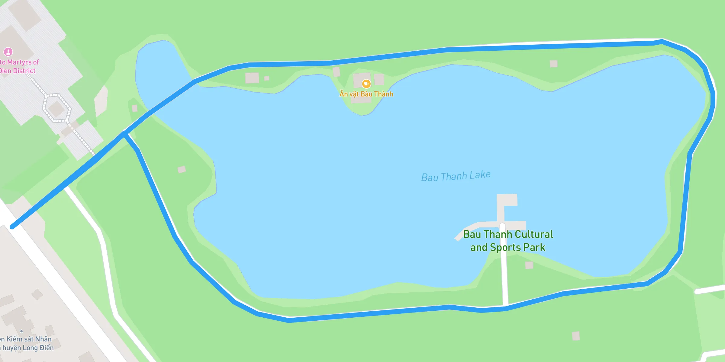
A scenic park in Bau Thanh with beautiful lake views, open spaces, and flat running trails, making it perfect for relaxed runs and nature lovers. **Bau Thanh Park Running Route: Nature Meets Convenience** Nestled in the scenic province of Ba Ria–Vung Tau, Bau Thanh Park offers a tranquil running experience amidst lush greenery and calming water features. Whether you’re a seasoned runner or simply looking to stay active during your travels, this park provides an accessible, community-focused environment. Below, find details to help you make the most of the Bau Thanh Park Running Route. ## 1. Park Overview - **Serene Landscape:** The park’s standout feature is its small lake, which attracts local wildlife and adds a refreshing ambiance. Shaded pathways and flower gardens enhance the natural appeal. - **Inviting Atmosphere:** Despite its popularity among residents, Bau Thanh Park rarely feels crowded. There’s plenty of space to find your stride. - **Fitness-Friendly Culture:** Early mornings and late afternoons see groups of walkers, joggers, and even tai chi practitioners, making it easy to connect with like-minded fitness enthusiasts. ## 2. Route Specifics 1. **Distance and Terrain** - The main loop around the park typically spans 1 to 2 kilometers, depending on the path you take. Some routes trace the lake’s edge, providing scenic water views. - The park’s terrain is mostly flat and paved, allowing for a hassle-free run suitable for all fitness levels. 2. **Ideal Running Times** - **Morning (5:30–7:00 AM):** Cool temperatures and fresh air. You can catch the sunrise reflecting off the lake. - **Afternoon (4:00–6:00 PM):** Softer sunlight and a communal, after-work energy. ## 3. Amenities and Tips - **Hydration:** Small vendors often set up near the park entrances, selling bottled water and fruit drinks. Bring your own water bottle if you plan a longer run. - **Sun Protection:** While there are shaded areas, it’s wise to wear sunscreen, a hat, or sunglasses, especially around midday. - **Restrooms:** Public facilities may be available at designated spots. Check local signs or ask a park attendant. - **Etiquette:** Be mindful of walkers and families. Keep to the side of the path if you need to slow down or stop. ## 4. Cultural Notes - **Community Engagement:** Locals frequently exchange friendly greetings. Saying “xin chào” (hello) is a simple way to join in the welcoming atmosphere. - **Clean Environment:** Dispose of any trash properly, and consider bringing reusable bottles or containers to reduce waste. - **Local Character:** Street vendors near the park might sell local snacks or souvenirs. Trying a fresh coconut post-run is both refreshing and culturally immersive. ## 5. Exploring Beyond the Park - **Dining Options:** A short walk or drive from Bau Thanh Park, you’ll find cafés and eateries serving Vietnamese staples like pho, banh mi, and iced coffee. - **Historical Sites:** If you’re in the area for more than a run, look into nearby temples, pagodas, or museums to learn about Ba Ria–Vung Tau’s rich heritage. - **Coastal Adventures:** The province’s stunning beaches are not far away, offering an alternative setting for a run or a relaxing cool-down by the sea. ### Conclusion The Bau Thanh Park Running Route stands out as a peaceful, beginner-friendly option in Ba Ria–Vung Tau. With its picturesque lake, walkable paths, and a friendly local scene, the park offers a welcome break from hectic city life. Whether you’re aiming to maintain your fitness routine or simply explore the area’s natural beauty, Bau Thanh Park invites you to lace up your running shoes and relish a rejuvenating escape in the heart of Vietnam’s coastal province.
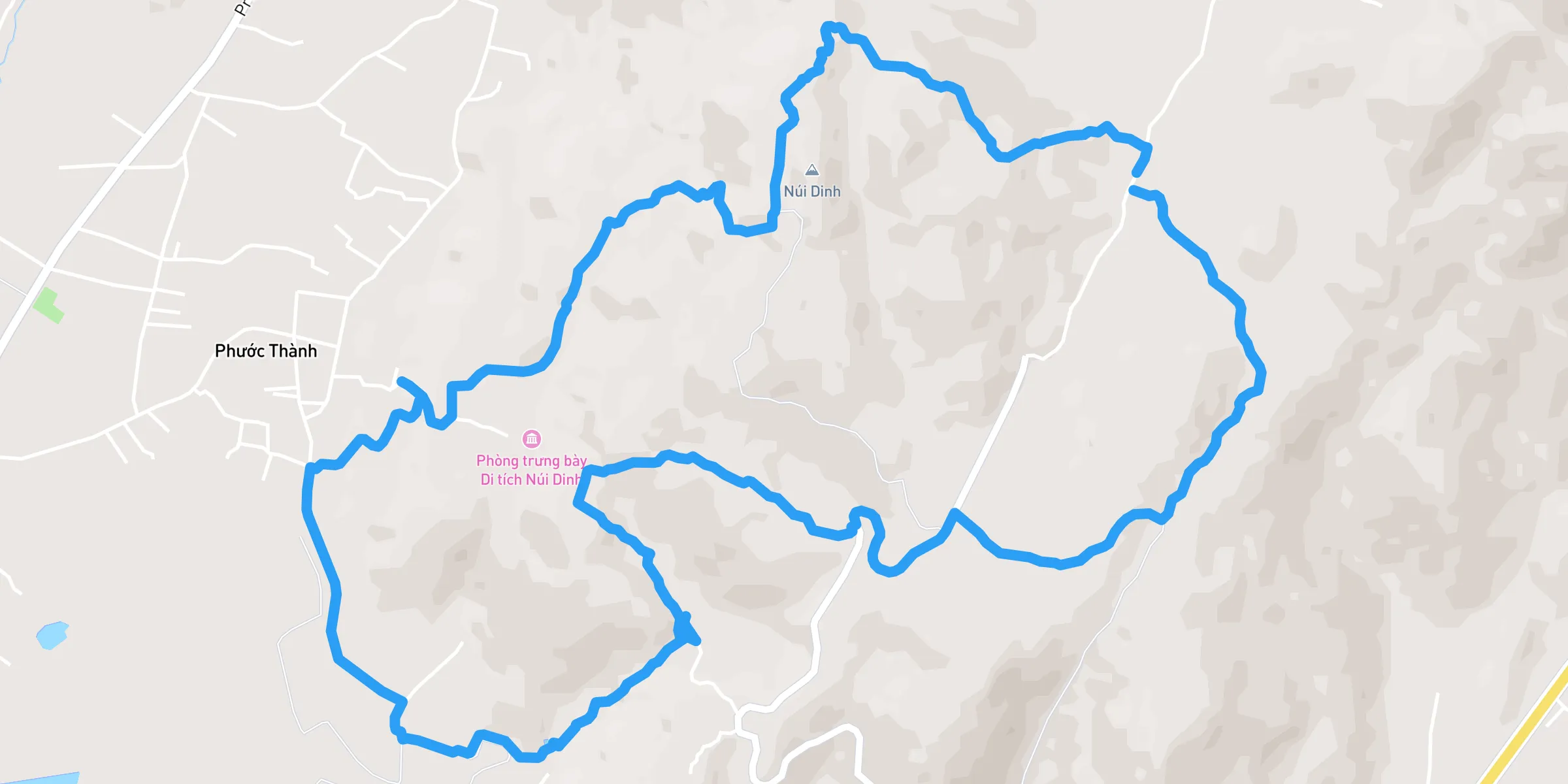
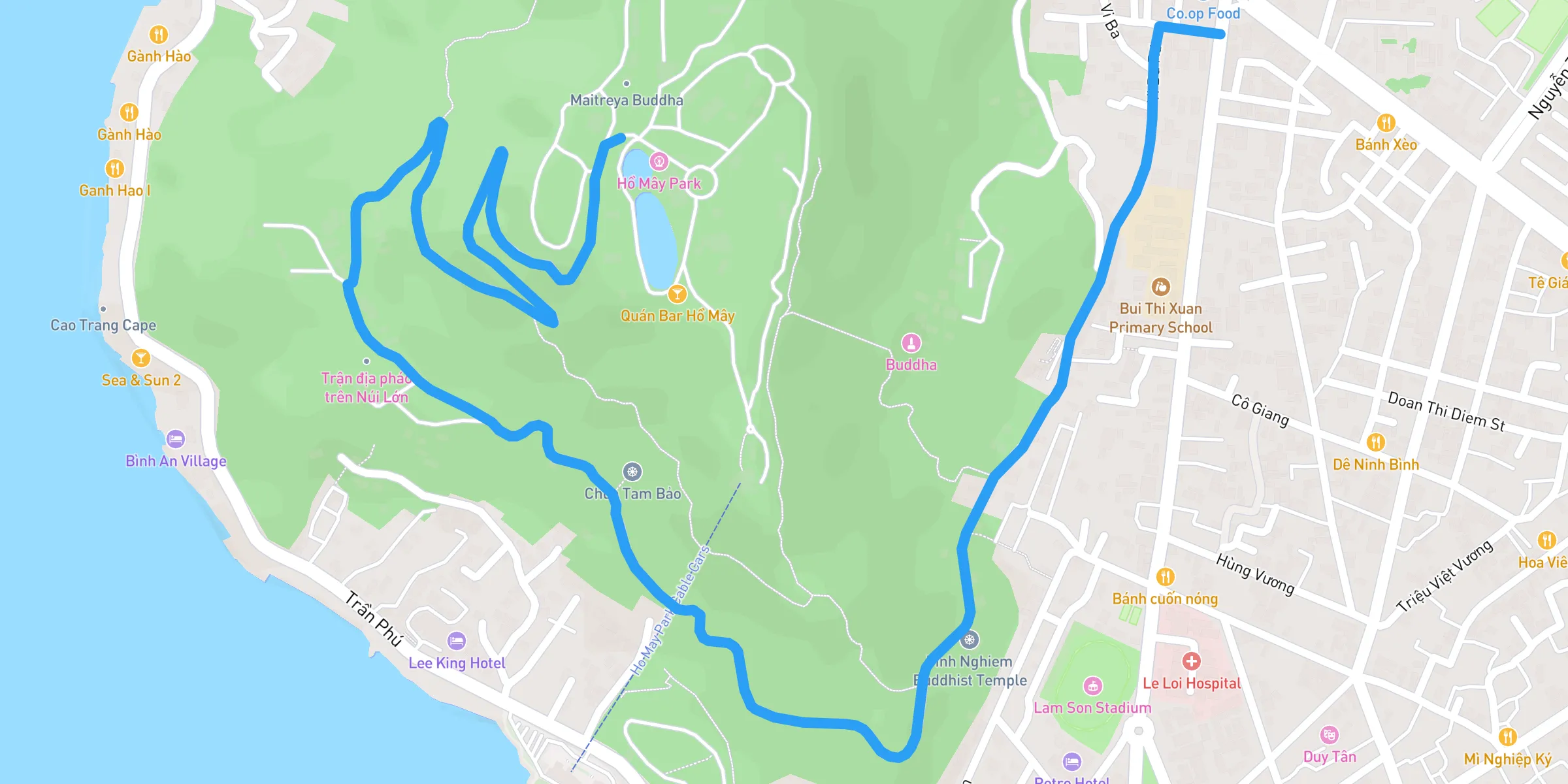
A challenging trail in Vung Tau with steep climbs, rocky paths, and stunning views from the summit. Perfect for trail runners seeking elevation. **Dinh Mountain Loop Running Route: A Trail Runner's Paradise** Nestled in Ba Ria–Vung Tau province, the **Dinh Mountain Loop** offers a challenging yet breathtaking running experience for those who crave adventure. Known for its rugged trails, panoramic views, and natural beauty, this route is perfect for trail runners looking to push their limits while immersing themselves in Vietnam's scenic landscapes. ## 1. Route Overview - **Location:** Dinh Mountain, Ba Ria–Vung Tau - **Distance:** Approximately 10 to 15 kilometers, depending on the chosen loop - **Elevation Gain:** 400–600 meters - **Difficulty Level:** Moderate to challenging, suitable for intermediate to advanced runners ## 2. Highlights of the Route - **Scenic Views:** Enjoy sweeping vistas of Ba Ria city, lush forests, and distant coastal lines as you ascend. - **Diverse Terrain:** Experience a mix of rocky paths, dense forest trails, and steep ascents that test your endurance and agility. - **Cultural Landmarks:** The route passes by Buddhist temples and ancient pagodas nestled within the mountain, adding a cultural touch to your run. ## 3. Trail Details ### Starting Point - **Dinh Mountain Base Camp:** This is the most popular starting area, offering parking and basic facilities. From here, multiple trailheads lead into the loop. ### Terrain Breakdown - **Ascent Section:** Steep and technical with rocky surfaces. Use caution during wet conditions. - **Forest Trails:** Shaded paths with tree roots and uneven ground. Ideal for cooling down after steep climbs. - **Ridge Run:** Open ridgeline segments with stunning views but minimal shade—sunscreen is a must. ### Estimated Completion Time - **Experienced Trail Runners:** 1.5 to 2.5 hours - **Casual Joggers/Hikers:** 3 to 4 hours ## 4. Safety Tips - **Hydration:** Carry at least 1.5 liters of water. There are limited water sources on the trail. - **Footwear:** Trail running shoes with good grip are recommended due to rocky and uneven terrain. - **Weather Awareness:** Avoid running during heavy rains as trails can become slippery. - **Navigation:** GPS apps or offline trail maps are helpful since some sections may lack clear markers. ## 5. Best Time to Run - **Early Morning (5:00–7:00 AM):** Cool temperatures and beautiful sunrise views. - **Late Afternoon (4:00–6:00 PM):** Softer sunlight, but ensure you have enough daylight to complete your run. ## 6. Points of Interest - **Buddhist Temples:** Tranquil spots for a quick rest or reflection. - **Viewpoints:** Several lookout spots offer perfect photo opportunities. - **Waterfalls (Seasonal):** After rainy seasons, small waterfalls appear along certain trail sections. ## 7. Post-Run Recommendations - **Local Eateries:** Sample authentic Vietnamese dishes at nearby food stalls. - **Relaxation Spots:** Visit nearby hot springs or take a short trip to Vung Tau Beach to cool down. ### Conclusion The **Dinh Mountain Loop Running Route** is more than just a run—it's an adventure through diverse terrains, cultural landmarks, and breathtaking vistas. Whether you're training for an ultra or just exploring Vietnam's natural beauty, this trail promises an unforgettable experience. Lace up your trail shoes and conquer Dinh Mountain!
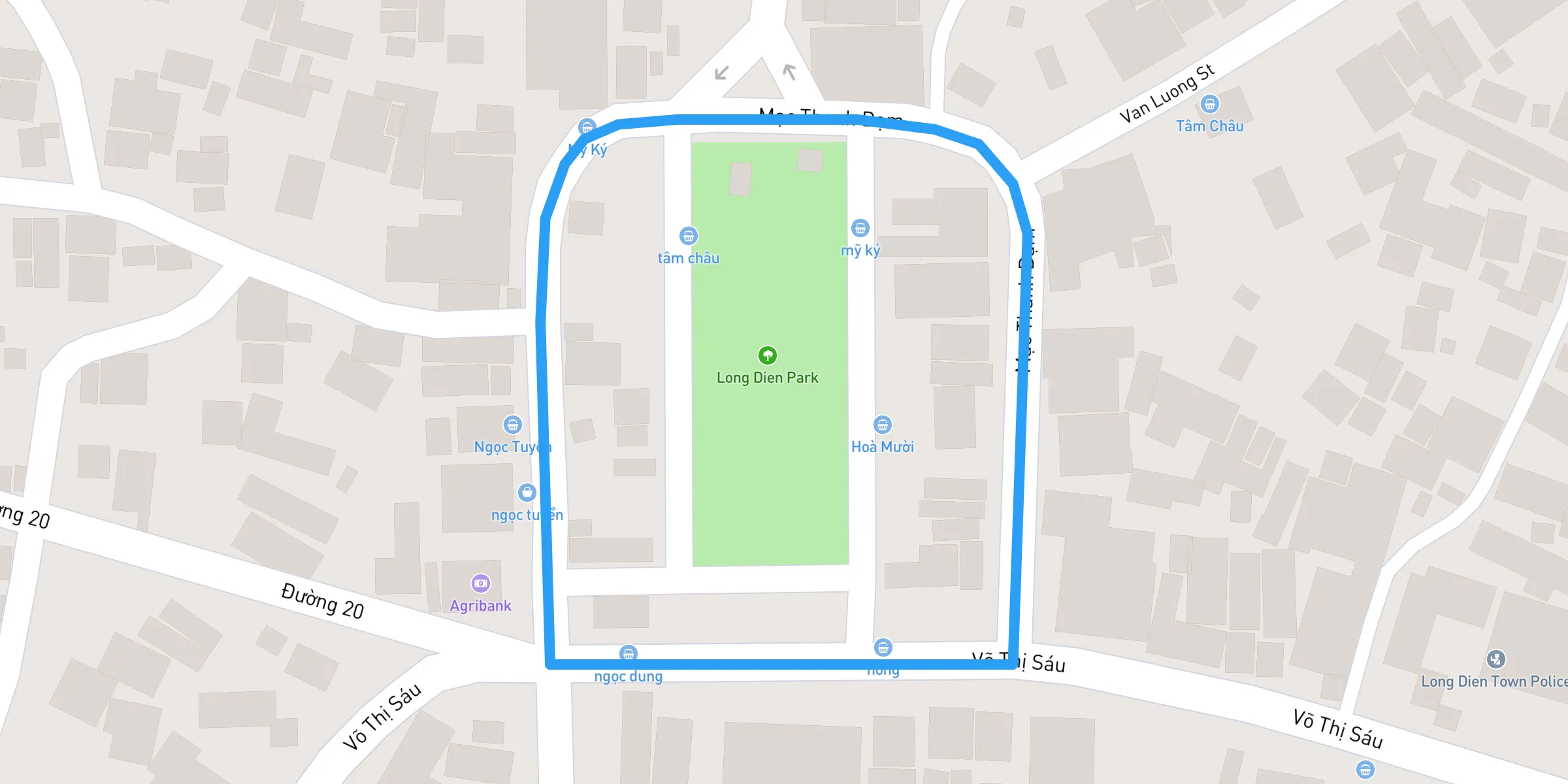
A vibrant park in Long Dien District with well-maintained running trails, fresh air, and scenic surroundings. Great for short runs and workouts. **Long Dien Park Running Route: A Scenic Escape for Joggers and Walkers** Long Dien Park, situated in the Long Dien district of Ba Ria–Vung Tau, offers a peaceful setting that’s ideal for runners, joggers, and walkers of all skill levels. Whether you’re a local searching for a new running path or a visitor eager to stay active while exploring the region, this park provides a nature-rich experience paired with convenient amenities. ## 1. Overview and Highlights - **Lush Green Trails:** The park’s paths meander through well-maintained lawns, shady trees, and vibrant flower beds, allowing runners to enjoy a refreshing environment as they work out. - **Peaceful Atmosphere:** Although popular among locals, Long Dien Park never feels overly crowded. You can comfortably set your pace without constant interruptions. - **Community Hub:** Morning and late afternoon often bring together groups of people practicing tai chi or group exercises. Observing or joining in is a great way to immerse yourself in local culture. ## 2. Running Path Details 1. **Distance and Terrain** - The main loop around Long Dien Park measures about 1 to 1.5 kilometers, depending on the route you take through the interior pathways. Most sections are flat and paved, making it suitable for both casual joggers and experienced runners. - For a more challenging workout, consider multiple laps or pick up your pace on straighter sections of the park. 2. **Ideal Running Times** - **Early Morning (5:30–7:00 AM):** You’ll experience cooler temperatures, fresher air, and fewer crowds. - **Late Afternoon (4:00–6:00 PM):** Enjoy softer sunlight and a welcoming community vibe as families and friends gather. ## 3. Safety and Comfort - **Hydration:** Bring a reusable water bottle, as water fountains might be limited. Alternatively, you’ll find small shops near the park selling drinks if you need a quick refill. - **Sun Protection:** Even with tree cover, the midday sun can be intense. Consider using sunscreen, a hat, or sunglasses to shield from UV rays. - **Footwear:** Regular running shoes are fine for the mostly paved paths, but be cautious of any uneven spots that can develop in outdoor parks. - **Etiquette:** Stick to the left side of the path (if customary) or follow any posted signage. Always be mindful of pedestrians or children at play. ## 4. Restroom and Amenities - **Public Facilities:** Check for restroom availability at the park’s main entrance or any visitor center. Hours may vary, so plan ahead. - **Exercise Equipment:** Some areas feature basic fitness installations like pull-up bars or stationary bikes. Use these stations to add variety to your workout. - **Seating and Shade:** Benches or sheltered spots dot the park, allowing you to cool down post-run or simply enjoy the scenery. ## 5. Local Tips and Culture - **Community Warmth:** Long Dien’s residents are friendly. Don’t be surprised if someone greets you with a smile or a quick “xin chào” as you pass by. - **Refreshments:** Street vendors often set up near the entrances, selling fresh fruit, juices, and local snacks that can be a tasty post-run treat. - **Weekends and Holidays:** Expect slightly larger crowds, including families and social groups, especially during public holidays or late afternoons. ## 6. Nearby Attractions - **Local Temples and Pagodas:** If you have the time, blend your fitness routine with a bit of cultural exploration by visiting nearby historical sites. - **Long Dien Food Scene:** Sample authentic Vietnamese dishes at small eateries and cafés in the surrounding area, known for fresh seafood and comforting soups. - **Beach Access:** Ba Ria–Vung Tau’s famous coastline is within a short drive, offering an alternative running surface if you fancy a more scenic, ocean-side run. ### Conclusion For those looking to maintain an active lifestyle while exploring Long Dien, the running route in Long Dien Park is a refreshing option. The gentle terrain, natural surroundings, and welcoming local culture make every lap a pleasure. Lace up your sneakers, take in the greenery, and enjoy a revitalizing run under the warm Ba Ria–Vung Tau sunshine.
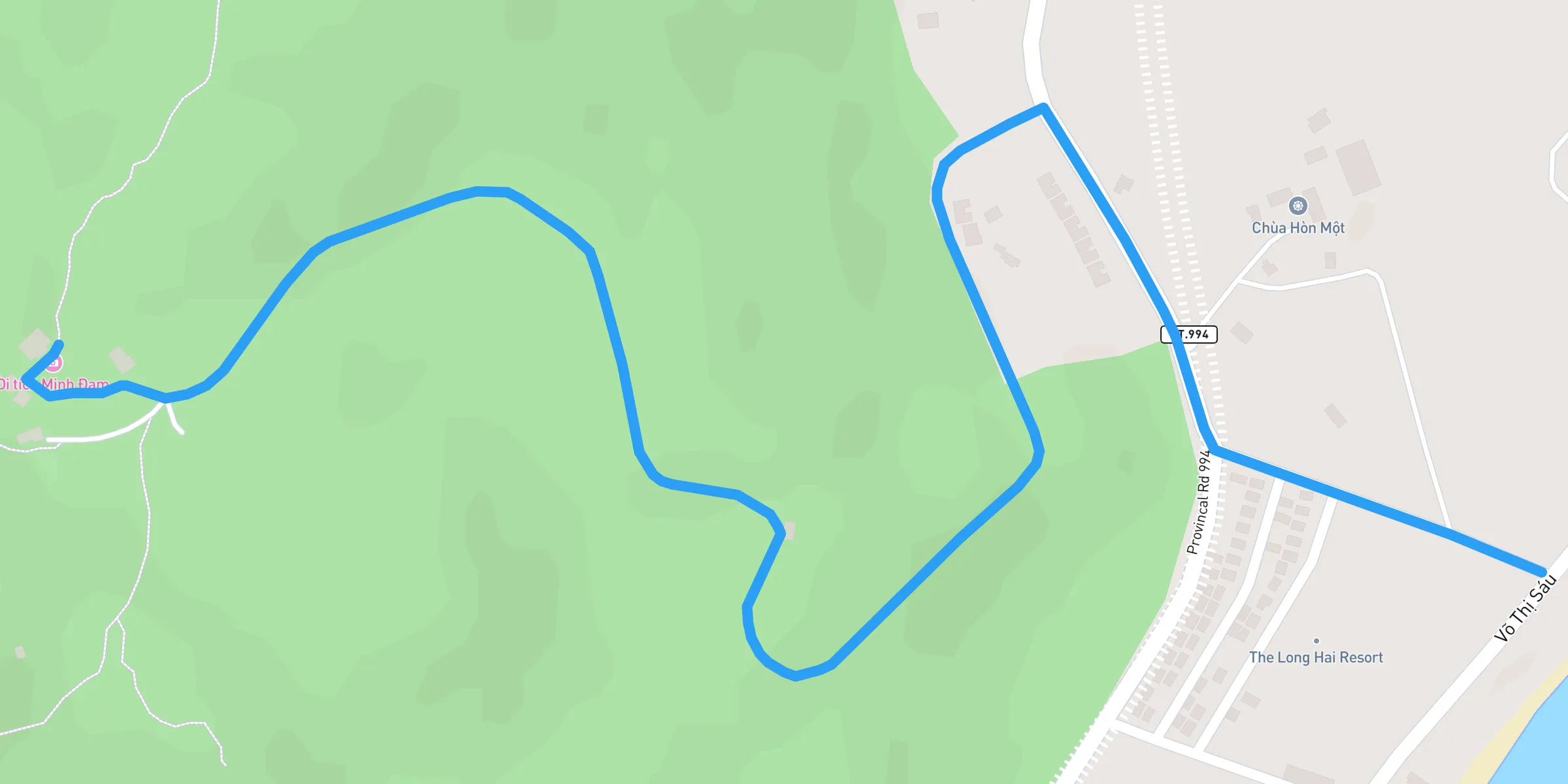
## Minh Dam Mountain Run: A Short but Intense Challenge The Minh Dam Mountain Run is a high-intensity 3km trail with a demanding **203m elevation gain**, making it a perfect choice for runners looking to challenge their climbing abilities. This short but steep route is categorized as **hard**, requiring strong endurance, agility, and mental toughness. Whether you are training for mountain races or simply looking for an uphill test, this route delivers an exhilarating experience. ### Route Details - **Distance:** 3km - **Elevation Gain:** 203m - **Difficulty:** Hard - **Terrain:** Steep inclines, rocky paths, and forested trails. - **Scenery:** Spectacular panoramic views, lush greenery, and historic war-era caves along the way. ### Why Choose This Route? 1. **Steep Elevation:** A great workout for runners aiming to improve hill climbing strength. 2. **Breathtaking Views:** Enjoy stunning landscapes from the summit of Minh Dam Mountain. 3. **Technical Terrain:** Rocky and uneven paths provide an exciting challenge for trail runners. 4. **Historic Significance:** Pass by war-era bunkers and caves, adding a cultural element to your run. ### What to Expect Along the Route - **Steep Inclines:** Be prepared for relentless uphill climbs right from the start. - **Rugged Terrain:** Uneven, rocky paths require careful footing and strong trail shoes. - **Limited Shade:** Bring hydration and sun protection, especially during midday runs. - **Wildlife & Nature:** The trail is surrounded by dense forests, offering a chance to see local wildlife. ### Tips for Runners - **Train for Elevation:** Incorporate hill repeats into your training for better adaptation. - **Use Proper Footwear:** Trail running shoes with strong grip are essential for stability. - **Hydrate Before and After:** Carrying water is recommended as hydration points are scarce. - **Best Time to Run:** Early mornings or late afternoons offer the best conditions. - **Pace Yourself:** Conserve energy on the steepest sections and use shorter strides. ### Post-Run Recovery - **Cool Down & Stretch:** Take time to ease your muscles after the steep climb. - **Enjoy the Views:** The summit provides a fantastic reward for your efforts. - **Refuel Smartly:** Bring snacks or head to nearby local food spots for a well-earned meal. The **Minh Dam Mountain Run** is a top-tier test of endurance and hill-running skills. If you're looking for a short but intense challenge, this route is a must-try!
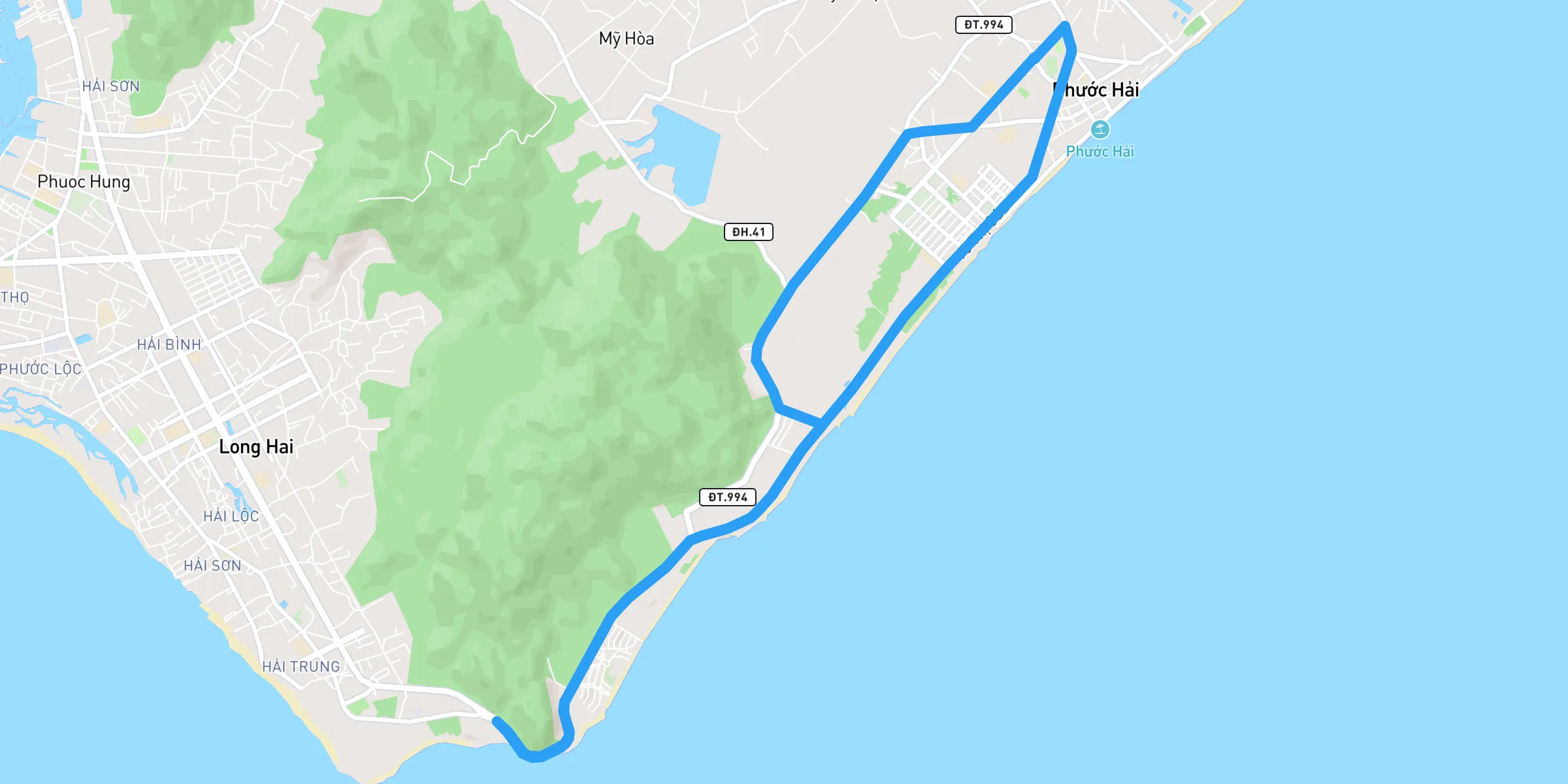
The **Phuoc Hai Township Running Route** is a demanding yet rewarding 17km course with an elevation gain of 79m. Designed for experienced runners looking to push their limits, this route offers a mix of scenic landscapes, rolling terrain, and a physically challenging experience. Whether you are training for endurance or seeking a tough workout, this run is sure to test your strength and stamina. ### Route Details - **Distance:** 17km - **Elevation Gain:** 79m - **Difficulty:** Hard - **Terrain:** A mix of paved roads and inclines, making it ideal for endurance training. - **Scenery:** Expect beautiful landscapes, open fields, and stretches of natural scenery that enhance the running experience. ### Why Choose This Route? 1. **Challenging Terrain:** The mix of inclines and rolling roads adds intensity to your training. 2. **Long-Distance Appeal:** Perfect for runners preparing for half-marathons or full marathons. 3. **Scenic Views:** The route takes you through natural landscapes and offers moments of serenity away from the city's hustle. 4. **Elevation Training:** The 79m elevation gain provides a great way to build endurance and strength. ### What to Expect Along the Route - **Rolling Hills:** Expect gradual climbs and challenging sections that will test your endurance. - **Limited Shade:** Be prepared for exposure to the sun, especially during midday runs. - **Road Conditions:** A combination of smooth paved roads and some rugged sections. - **Minimal Facilities:** Plan ahead as convenience stores or water stops may be limited along the route. ### Tips for Runners - **Hydrate Well:** Carry enough water or plan hydration stops along the way. - **Best Time to Run:** Early mornings or late afternoons to avoid the heat. - **Footwear:** Use cushioned running shoes to support your feet on mixed terrain. - **Pace Yourself:** Given the distance and elevation, maintain a steady pace to conserve energy. ### Post-Run Recovery - **Cool Down & Stretch:** Take at least 10 minutes to cool down properly after finishing. - **Refuel:** Look for nearby local eateries or bring recovery snacks to replenish lost nutrients. - **Hydrate:** Drink water or electrolyte-rich beverages to recover efficiently. The **Phuoc Hai Township Running Route** is a top choice for runners looking to test their limits on a hard 17km course. If you're up for the challenge, lace up your shoes and take on this endurance-building route today!
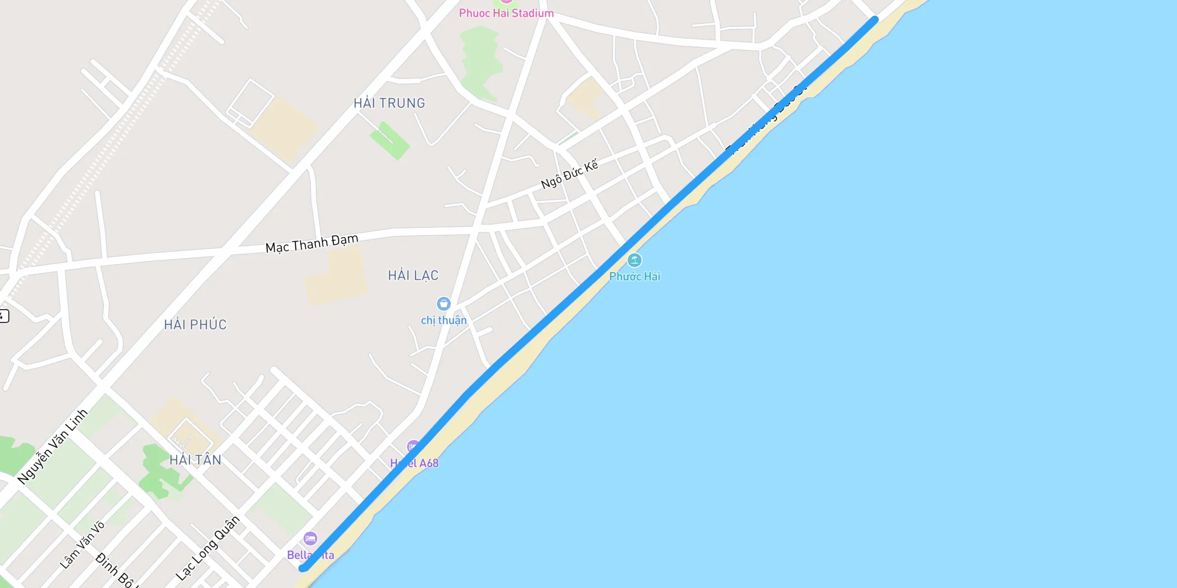
Phuoc Hai Township is a quaint coastal town located in the Ba Ria–Vung Tau region of southern Vietnam. It’s known for its charming fishing community, scenic beaches, and peaceful atmosphere. Visitors can observe local fishermen bringing in the day’s catch, explore hidden coastal paths, and sample fresh seafood at the bustling markets. Whether you’re seeking a relaxing seaside getaway or a taste of authentic Vietnamese coastal life, Phuoc Hai Township offers a welcoming escape from the crowds. ## 1. Overview & Highlights ### A Unique Slice of Coastal Life - Authentic Fishing Community: The Loop immerses you in daily village rhythms, offering a fascinating lens into local culture. You’ll see fishermen unloading their catch, bustling markets, and colorful boats along the shore. - Stunning Ocean Views: The route follows sections of the running in Ba Ria Vung Tau coastal paths, so expect scenic glimpses of the water and refreshing sea breezes. ### Ideal Times to Run - Early Morning (5:30–7:00 AM): Cool temperatures, active fish markets, and a gorgeous sunrise over the sea. - Late Afternoon (4:00–5:30 PM): Lower sun intensity, soft golden light, and a relaxed village vibe. These times are also great for trail running in Phuoc Hai Township if you’d like to extend your run into nearby hilly areas or coastal trails. ## 2. Route Details 1. Starting Point: - Many runners begin near the central fish market by Phuoc Hai Beach. It’s a well-known spot for locals and easy to locate. 2. Distance & Terrain: - Expect a 2 kilometer loop, weaving through narrow streets and along the coast. While parts are paved and relatively smooth, some sections may be uneven—characteristic of running trails near Phuoc Hai Beach. 3. Navigation & Traffic: - Roads can be shared by pedestrians, bicycles, and motorbikes. Use a GPS or map app; signage is limited but locals are friendly if you need directions. ## 3. Points of Interest 1. Fish Market Strip - A lively stretch teeming with local vendors. Early mornings here are an exciting fusion of sights and aromas, making it a prime attraction within this Ba Ria Vung Tau running guide for tourists. 2. Local Shrines & Temples - Scattered along the route, these small temples offer a peaceful contrast to the busy market. If you choose to pause, remember to show respect and follow any posted rules. 3. Coastal Overlook - Parts of the loop run parallel to the water. Breathe in the salty air and enjoy panoramic views—one of the main draws of running in Ba Ria Vung Tau coastal paths. ## 4. Practical Tips ### Restroom Options - Local Cafés & Shops: - Grab a quick beverage and use their restroom. This is also a good chance to pick up a sports drink if you need one. ### Hydration & Nutrition - Sports Drink Stops for Runners in Ba Ria Vung Tau: - Small convenience stores or roadside stalls stock bottled water and popular Asian electrolyte drinks (like Pocari Sweat or 100 Plus). - Fresh coconuts are a must-try, providing a natural energy boost. ### Safety Essentials 1. Traffic Awareness: - Narrow roads mean staying alert. Run single file and yield to faster-moving vehicles or bicycles. 2. Dog Awareness: - Stray or semi-stray dogs are common. Stay calm and avoid sudden movements if approached. 3. Sun Protection: - Use sunscreen, wear a hat, and bring sunglasses. The coastal sun can be intense, especially later in the morning or midday. ## 5. Cultural Etiquette - Dress Modestly: - While running gear is acceptable, cover up if entering shrines or indoor market areas. - Local Interaction: - A simple “xin chào” (hello) can break the ice. Many locals will happily direct you if you appear lost. ## 6. Extending Your Run If you’re craving more distance or variety: - Minh Dam Mountain Footpaths - For those who love trail running in Phuoc Hai Township, heading toward the foothills provides a blend of forest and sea views. - Longer Coastal Routes - Connect the Fishing Village Loop with neighboring roads along smooth running routes in Ba Ria Vung Tau for a longer workout. ## 7. Post-Run Treats - Bánh Mì or Noodles: - Refuel with local street food—fresh ingredients, quick service, and budget-friendly. - Iced Vietnamese Coffee (Cà Phê Đá): - A revitalizing pick-me-up after a run, often served sweetened with condensed milk. ### Conclusion The Phuoc Hai Fishing Village Loop stands out among the best running routes in Ba Ria Vung Tau, offering an authentic encounter with Vietnam’s coastal culture. Whether you’re a casual jogger or an avid runner seeking smooth running routes in Ba Ria Vung Tau, this loop delivers scenic beauty, cultural immersion, and convenient sports drink stops for runners in Ba Ria Vung Tau. Add it to your list of best jogging spots in Ba Ria Vung Tau and discover why running at Phuoc Hai Township\* is a must-do for visitors looking to go beyond the usual tourist trails. Lace up, stay hydrated, and savor every moment of this memorable route!
Looking for **where to run in Ba Ria Vung Tau**? The **Tuong Ky Mountain Run** is a challenging yet rewarding **4.1km trail** with an elevation gain of **231m**, located in **Ba Ria-Vung Tau Province, Vietnam**. This demanding route is one of the best **running routes near me** for those seeking adventure, making it a must-try for trail runners, fitness enthusiasts, and outdoor lovers. The rugged terrain and breathtaking summit views provide an unparalleled experience for anyone wondering **where to run near me** in southern Vietnam. ### Why Choose Tuong Ky Mountain Run? This route offers a thrilling mix of elevation, natural beauty, and technical difficulty. Unlike urban **routes run near me**, the **Tuong Ky Mountain Run** immerses you in nature while providing a serious workout. It is one of the best **run routes near me** for those looking to improve their endurance and agility. ### Running Details - **Location:** Ba Ria-Vung Tau Province, Vietnam - **Distance:** 4.1km - **Elevation Gain:** 231m - **Difficulty:** Hard - **Surface:** Steep inclines, rocky paths, and rugged terrain - **Best Time to Run:** Early mornings (6:00 AM - 8:00 AM) or late afternoons (4:30 PM - 6:00 PM) to avoid extreme heat ### Highlights Along the Route - **Challenging Climbs:** Expect steep inclines that push your endurance to the limit. - **Panoramic Views:** The summit provides spectacular views of the surrounding landscapes and coastline. - **Remote & Peaceful:** Unlike crowded city **running routes near me**, this trail offers a tranquil and immersive nature experience. - **Technical Terrain:** A mix of rocky paths and uneven surfaces will test your agility and strength. ### Tips for Runners - **Hydration Strategy:** Carry enough water, as hydration points are scarce. - **Proper Gear:** Wear trail running shoes with a strong grip to handle the rocky sections. - **Sun Protection:** Limited shade means you should bring sunscreen and a cap. - **Respect the Environment:** Stick to designated paths to protect the natural surroundings. ### Where to Find Toilets, Snacks, and Sports Drinks - **Toilets:** There are no public toilets available along the trail. The nearest restrooms can be found at local cafés and eateries near the starting point. Plan accordingly before beginning your run. - **Snacks:** Small vendors and local markets near the base of the mountain offer fresh fruits, packaged snacks, and quick bites for pre-run or post-run fueling. - **Sports Drinks:** Convenience stores and roadside stalls near the entrance of the trail provide bottled water, sports drinks, and coconut water to help with hydration. ### How to Get There For those looking for **where to run in Vietnam**, Tuong Ky Mountain is a great destination. It is accessible by motorbike or car from Ho Chi Minh City, approximately a **2-hour drive** away.  ### Post-Run Recovery - **Cool Down & Stretch:** Take time to prevent muscle stiffness. - **Enjoy the Summit:** Absorb the incredible views and take in the accomplishment. - **Refuel:** Nearby local eateries in Ba Ria-Vung Tau offer authentic Vietnamese dishes to help you recover after your intense workout. ### Final Thoughts For runners wondering **where to run in Ba Ria Vung Tau**, the **Tuong Ky Mountain Run** is a top choice. The combination of steep climbs, technical trails, and stunning views makes it one of the most rewarding **running routes near me** for those in southern Vietnam. Whether you're a seasoned trail runner or someone looking for a new adventure, this **run route near me** is a must-try. Lace up your shoes and explore one of the best **routes run near me** today at **Tuong Ky Mountain**!
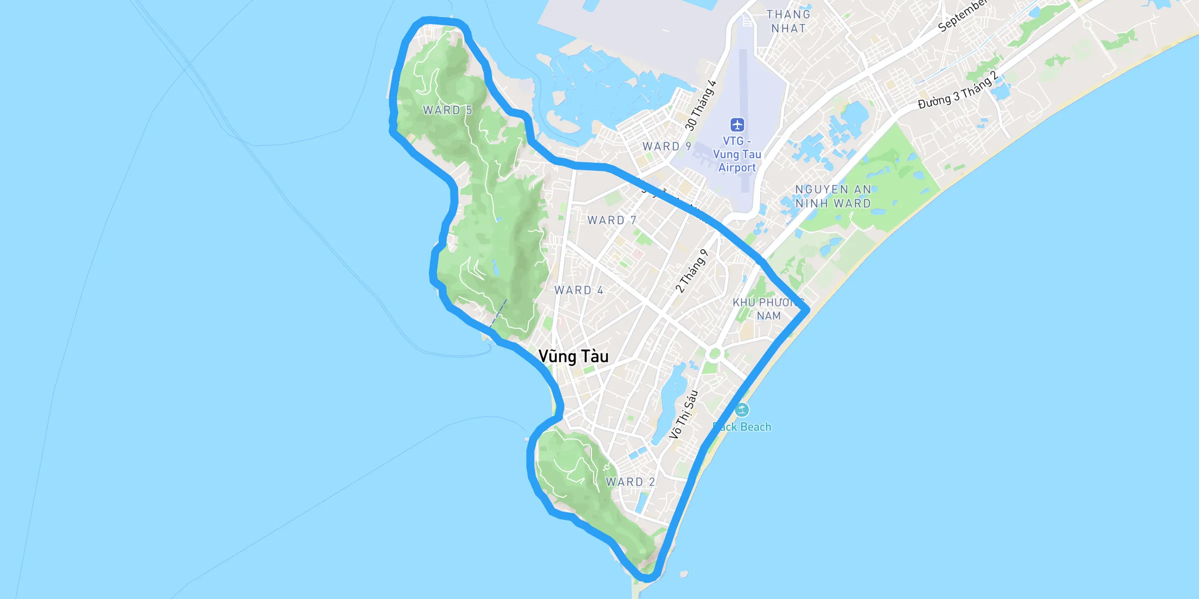
A scenic urban loop around Vung Tau City, offering a mix of coastal views, city streets, and vibrant local life. Ideal for long, steady runs. ## 1. Route Overview - **Location:** Vung Tau City, Ba Ria–Vung Tau Province - **Distance:** Approximately 10 to 20 kilometers, depending on the chosen loop - **Elevation Gain:** Minimal, mostly flat with gentle inclines near coastal roads - **Difficulty Level:** Easy to moderate, suitable for all fitness levels ## 2. Highlights of the Route - **Seaside Views:** Enjoy the refreshing ocean breeze along Thuy Van Beach and Back Beach (Bai Sau). - **Iconic Landmarks:** Pass by the Christ of Vung Tau statue, Lighthouse Hill, and Front Beach Park. - **Local Culture:** Experience the city’s lively streets, bustling markets, and friendly local atmosphere. ## 3. Route Details ### Starting Point - **Front Beach Park (Bai Truoc):** A popular starting spot offering ample space, ocean views, and nearby amenities. ### Key Segments - **Seaside Stretch:** Run along Thuy Van Street for stunning coastal scenery and cool breezes. - **City Loop:** Pass through the vibrant city center, with cafés, street food vendors, and colonial architecture. - **Lighthouse Hill (Optional):** Add a short detour for a mild uphill challenge and panoramic views of Vung Tau Bay. ### Estimated Completion Time - **Experienced Runners:** 45 minutes to 1.5 hours - **Casual Joggers:** 1.5 to 2 hours ## 4. Safety Tips - **Hydration:** Carry a water bottle, especially during hot hours. Convenience stores along the route offer refreshments. - **Traffic Awareness:** Stay alert when crossing busy streets. Use pedestrian crossings where available. - **Sun Protection:** Wear sunscreen, a hat, and sunglasses to protect against the tropical sun. ## 5. Best Time to Run - **Early Morning (5:00–7:00 AM):** Enjoy cooler temperatures and peaceful streets before the city wakes up. - **Late Afternoon (4:00–6:00 PM):** Golden-hour light enhances the scenic coastal views, with milder heat. ## 6. Points of Interest - **Christ of Vung Tau:** A towering statue offering a scenic backdrop for photos. - **Vung Tau Lighthouse:** Panoramic city and ocean views from the hilltop. - **Local Markets:** Vibrant spots to experience daily life and grab fresh fruits post-run. ## 7. Post-Run Recommendations - **Beach Cool-Down:** Take a dip in the ocean at Back Beach to refresh after your run. - **Local Delicacies:** Refuel with local dishes like bánh khọt (crispy pancakes) or fresh seafood at seaside restaurants. - **Cafés and Juice Bars:** Relax with a Vietnamese iced coffee or fresh coconut juice from nearby vendors. ### Conclusion The **Vung Tau City Loop Running Route** is more than just a workout—it’s an immersive journey through the city’s stunning coastlines, rich history, and vibrant local culture. Whether you’re chasing a new personal best or enjoying a leisurely jog, Vung Tau’s scenic charm will inspire every step. Lace up your running shoes and explore the city like never before!